With little time to plan, we immediately began spit balling. We e-mailed back and forth, sharing links from Mountain Project to climbs that looked like they might possess the right combination of challenge, adventure, and access. We only had five days, so we knew we wouldn't be able to trudge too far into the wilds. Plus, I wanted to maximize the Yosemite training potential of this trip, which meant that pure rock routes would be the flavor du jour. That ruled out some of the big boys of the range. But not to worry; this was the Cascades, after all. There were still plenty of climbs that fit our narrow selection criteria.
 |
| Liberty Bell Group. Photo from Mountain Project. |
The Liberty Bell group, which includes five granite spires, is tucked neatly into a hairpin turn in the North Cascades Highway. Conveniently, this meant that the approach would be trivial by Cascades standards. We decided that these routes would be a good starting point to get a feel for the rock and the range as a whole.
With that settled, I was now free to turn my attention to travel logistics. My flight left DCA on the evening of August 16th, with one connection in Boston. JetBlue claimed they would get me into SeaTac by midnight. My plan was to pick up a rental car, then nab a few hours' sleep at an airport hotel. Theoretically, that would have allowed me to get up early and drive to Chelan -- where Spencer was living it up at a lake-side resort for a business conference -- then high-tail it to the Liberty Bell group and do a quick warm-up route. I've traveled enough for climbing that I should have known better. The capricious nature of modern air travel makes smash-and-grab trips like this difficult to time. I ended up with a three-hour delay in Boston and arrived, red-eyed and strung out, around 2:30 a.m. Seattle time.
Getting a hotel now seemed like a waste. I considered taking a short nap in the airport, but a cup of coffee gave me the (false?) confidence to attempt the drive to Chelan on no sleep. The B-team employees at the Hertz counter informed me that the only mid-sized car they had left was actually a Nissan pick-up truck. I told them that would be fine, since I was going into the mountains. After a few attempts at upselling me, including into a Mustang convertible, they realized it was futile and tossed me the keys to the truck.
The drive to Chelan required one large cup of coffee and one Red Bull, but was mostly uneventful save for one near miss. About two hours in, I had to test the brakes on the ol' Nissan when a doe ran out in front of me. Had I been in that Mustang, I may have had some deer jerky for the mountains, but the Nissan was much slower. Disaster averted.
I rolled into Chelan just after day break and woke Spencer from his happy holiday slumber over there on Melody Lane.
(click to play)
If any of you are looking for any last minute gift ideas for me, I have one.
After a two-hour nap, we ate breakfast, checked out, and headed into the mountains.
An anxious three-hour drive brought us into the Cascades. At every gap, I craned my neck, trying to catch that chilling feeling that only a steep mountain can offer. Gratefully, we soon rounded a corner and caught a glimpse of the top of a group of towers that left no doubt as to its identity. Liberty Bell and its sister spires were majestic from a distance. Their splendor was hardly diminished when we got closer and saw the steep scree slope culminating in the nadir of what appeared to be hundreds of feet of clean granite. According to online descriptions, the approach would be easy and we would soon be karate chopping and finger locking up splitter cracks.
When we hit the hairpin, we parked the truck and realized we had yet to choose our first route. Each of the group's five spires held multiple quality routes, and thus far all of our attention had been directed towards just getting there. Should we go for the spires' free-climbing jewel today -- The Passenger -- or save it for tomorrow? Should we start with something short and/or moderate to get a feel for the rock?
We settled on an elegant compromise. Since we were tired and only had a half day, we would attempt the West Face on North Early Winter Spire. At 5.11a, this was a more forgiving option than The Passenger, and the approach was also easier. At the same time, if we lost the next day to poor weather, at least we would have done a fine, challenging route.
 |
| The West Face starts at the lower left corner of the left-hand spire. It climbs up through moderate terrain until reaching the exposed headwall, where it gains thin cracks that lead up to the summit through the light streak near the top of the picture. |
The West Face
After racking up in the parking lot, we started our hike in the heat of the early afternoon. I've never been to the North Cascades, but I'm assuming that 90+ degrees is unusual, even for mid-August. I was sweating profusely before breaking tree line, and by the time we reached the base of the route, I was cursing myself for not being in better shape. Spencer had spent the last week climbing hard routes in the Tetons and was already in mountain shape. He hardly broke a sweat as his long stride set a pace that I could barely follow.All I could do was put my head down and enjoy the views between sucking wind and trying to find excuses to stop for a few seconds: "Hey Spence, maybe we should consult the guidebook one more time, just to make sure we're on the right track."
 |
| Ever obliging, Spencer consults the guidebook while I ponder my fitness. |
The start of the route was obvious, and when we arrived, I threw down my gear and relieved myself at the base of the first pitch. We began stuffing our climbing pack and putting on our harnesses when Spencer looked up and saw a mountain goat coming around the corner.
Now, I should mention, on the drive from Chelan, we somehow got on the topic of alpine wildlife, and Spencer told the story of a mountain goat recently goring a hiker to death somewhere in the nearby Olympic Range. No shit, we had just had this discussion when, of course, Bambi with horns comes waltzing around the corner. Showing no fear, our bovine friend walked right up to within five feet of us and started licking the salt from my urine puddle. At this point, I was happy to have the opportunity to film wildlife up close. I broke out my iPhone and started recording while Spencer racked up. While I was filming, a second and much larger goat showed up. As you can tell from the embedded video, I started to get a little nervous, especially given that I would be left alone on the ground to fend for myself and ward off a two-pronged pincer attack from the devil-horned aggressors while Spencer led the first pitch.
I didn't let Spencer leave the ground until the goats lost interest and adroitly scaled a parallel ridge, where they took up shop and watched us, likely waiting to ramsack (get it?) our packs as soon as we were out of rappel range.Since we naturally assumed the worst from these beautiful creatures, we decided to hang the packs before leaving the ground.
 |
| Spencer follows the 5.9 undercling traverse. |
 |
| The crux finger crack. It's all about the feet. |
Spencer followed cleanly. There was hardly a need for a re-rack, as Spencer had removed most of our gear from my long lead. He was off linking the final two pitches in no time. The thin crack continued for another 50 feet, offering great locks and laybacks. This part went at about 10c and was the best climbing on the route. The crack then widened a bit and got easier until a bolt marked a slabby traverse. After the traverse, Spencer built a belay on a sloping ledge and brought me up. From there we scrambled to the summit at sunset and took in the views.
 |
| Spencer scrambles to the summit. |
 |
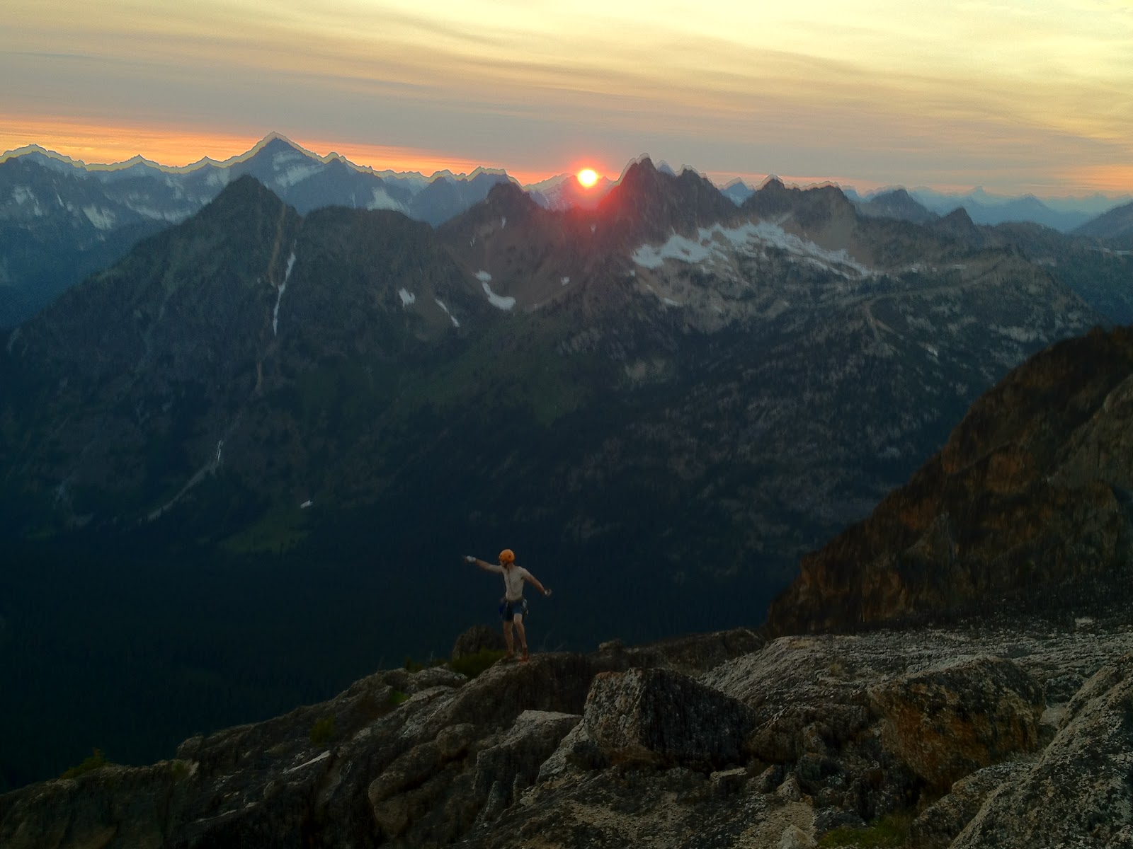
| Summit hero shot. |
 |
| Namaste. |
It was nearly 10 by the time we got back to the truck, but we were fairly confident we could find some food. It was the high season in the Cascades, and many of the small towns we had driven through east of Washington Pass were packed with bikers and tourists. Surely some place would still be offering food at this hour. Well, we were wrong. We ended up having to buy frozen food at the local service station. Luckily, we did manage to find a flea bag motel that still had an available room with an oven in which we cooked our Hot Pockets. Mmm ... nothing like a rewarding meal after a day in the mountains.
The Passenger
Two hours of sleep over the previous two days had left me utterly exhausted. After staying up until 2 a.m. to cook our Hot Pockets in the oven, I crashed hard. It seemed like only five minutes had gone by when the alarm went off the next morning, sometime around 9. We took our time getting out of the hotel and finding breakfast. Our confidence was high after going car to car so quickly on The West Face, and we would have even more time to work with for today's route. Why hurry? |
| Spencer, after negotiating the scree and finally gaining the ridge. |
Scree slopes are never an afterthought. I can't describe in words how much I hate them. This is a lesson I have had to learn several times. We had to fight for every foot of elevation we gained on that approach. Every footfall carried the possibility of starting a mini avalanche of dirt, rocks, and human, and setting you back a meter or two. Every 10 minutes my approach shoes would pick up another painful hitch hiker. Worst of all, this was all happening on an east-facing slope, at the hottest time of the day. After more than two hours, we finally gained a ridge of solid rock that we could follow to the base of the route, but I was certainly worse for the wear. Dusty, bloody, sweaty -- this route had me beaten even before we started climbing.
 |
| The first pitch. Photo from Mountain Project. |
I took the second pitch, which was a full-value 11b, described in the guidebook as "hard to onsight for the grade." That proved true, and I took a fall at the crux, giving myself a nasty rope burn on my ankle in the process. I unlocked the sequence on my second go, but the crux stays on you, and it took me some time to finish the pitch. Despite being slow, the climbing was excellent and the rock was clean.
 |
| Start of the crux on the second pitch. Photo from Mountain Project. |
Gazing up at the long crux pitch as the sun was setting, we were faced with a tough decision. We knew we couldn't finish the route in daylight. After the crux, there were two long 5.10c pitches, followed by a 5.7 pitch to the summit. Once on top, we would still need to descend the South Arete -- a route neither of us was familiar with -- then slide back down the steep scree slopes to our truck, all in the dark. We decided that we weren't up for a potential epic on our second day and, sadly, made the decision to bail.
We were, however, hoping that we could at least climb the crux pitch before we came down. After sussing it out, we didn't see a satisfactory way to engineer it. At 120 feet with no permanent anchor, there would be no way to rappel the pitch easily, without leaving gear behind. What we had thought would be a relaxed half-day route ended up kicking our butts. A late start, nasty approach, and tough climbing had whooped us, and we turned tail and ran. But, having done the first three pitches, I would gladly recommend this route to anyone. It was high quality. Just, please, don't approach via the scree slope!
Forbidden Peak -- South Face Direct
For our final route in the Cascades, we wanted to do something bigger and more committing than a road-side granite spire. We tossed around some ideas, including the Southern Picket Range and the Gunsight Range, but in the end we chose a slightly more accessible objective -- the South Face Direct of Forbidden Peak.Forbidden Peak is located in Boston Basin, right in the heart of the North Cascades. Should you make it to the summit, you'll find yourself surrounded by peaks -- Shuksan and Baker to the north; the Pickets to the northwest; Sahale and Sharkfin to the east; and, if you can manage to look past Johannesburg dominating the southern skyline, you'll see Rainier, St. Helens, and Glacier Peak.
 |
| Marmot waits patiently to gnaw our brake lines. |
 |
| Boston Basin on the approach, with Forbidden Peak right of center. |
After a long detour to avoid a gushing, glacier-fed stream, we made it to high camp sometime between 5 and 6 p.m. We found a flat spot on the moraine and tossed our gear down. Knowing it would get dark and chilly soon, we started our camp chores immediately and had our tent set up and water filtered in minutes.
Over a dinner of pasta, avocado, Vienna sausages, and Old Chub, we discussed our objective. I'm of the mindset that a climbing trip isn't successful unless you have one big, audacious goal. Oftentimes that goal will be over reaching by a good margin, but nevertheless, you should prepare as if you mean to be successful. Apparently Spencer has the same idea, because he suggested we not only climb the South Face Direct to the summit of Forbidden Peak, but then link that into a traverse of the mile-long ridgeline between Forbidden and Mount Torment. (You can see the ridgeline in the picture above, leading to the summit of Torment on the far left of the photo.)
 |
| Relaxing at high camp, with J'burg in the background. |
To top it all off, we needed to carry all of this stuff up the steep south face, which was going to be at least 7 pitches of technical climbing, some of which would be 5.9 - 5.10. Spencer seemed optimistic, so I didn't mention more than once or twice that I thought this was an epic waiting to happen. But, it sounded like an adventure, and that's what I was looking for. I had no right to complain.
 |
| Line of first ascent in white. Our rough line (to the best of my recollection) in red. |
The route description in this book may leave something to be desired, depending on how you look at it. Although the face itself is roughly 800 feet, the book only describes the first two pitches. These first two pitches should, according to the book, get you through the overhanging band onto the slabby middle of the face. From here, you are supposed to funnel right under the summit and climb straight up. It does add that the last pitch is a left facing corner and goes at 5.10. But that's it.
If you're looking for an alpine oddyssey into unknown terrain, then this description is great. It's like a mad-lib or a choose your own adventure climb. But if you are aiming for speed, then you shouldn't get too caught up in trying to stay on the original line. That was perhaps our mistake.
I was too focused on trying to find the original route and stay glued to it when I should have been more worried about just moving upwards. I had never before been on an alpine face where I was climbing into unknown terrain. I knew we weren't "on route," and I didn't even know if the line would go. The rock was bad in lots of places, and good protection was far more sparse than I was used to. It was a bit stressful, and I moved slowly.
 |
| Taking the lead below the overhanging band. |
 |
| Slabby middle of the face, high above the glacier. |
We both knew we probably weren't on route. The only sign of previous ascents on the entire climb was one old rusty angle in the middle of the face. At this point, we weren't too worried about it. Retreat would have been difficult, and we were now committed to finishing our route. We were climbing in Malcom X style, just trying to get to the top. What did it matter if someone had been there before or not?
The last pitch did turn out to be a 5.10 corner, but it was nowhere near the one described in the guidebook. I led it and Spencer followed cleanly with the heavy pack. In my opinion, it was by far the best pitch on the route. From our top out on the ridge, it looked like we could tag the summit in just a few meters. It turned out we were about 3 pitches of 5.6 scrambling from the true summit. By the time we made it to the top, it was close to 6 p.m., and we had been climbing for nearly 12 hours.
 | ||||
| Spencer topping out on the ridgeline after the crux pitch. |
 |
| Clouds belie the true immensity of J'burg's NE face. |
 |
| Alpine style. |
What Does It Mean?
It's tough to avoid the literary trap of writing about the "meaning" of a climb. Most of the time it's done poorly, and doesn't translate well to most readers. It's difficult not to sound pompous or preachy, and even harder not to sound trite and faux intellectual. But I will attempt it here, because this climb did mean something to me.I don't subscribe to the theory that a climb has to have risk to be meaningful. As a tribe, we climbers often give effusive praise to the riskiest climbs and the boldest climbers, and that's fine. But to your typical weekend warrior, simply getting up his or her first 5.10 or 5.11 trad line can, and should, be meaningful. I state that first because, this time, I feel like a little more adventure than I'm used to helped make the South Face of Forbidden Peak one of my most memorable climbs ever.
I mentioned above that about halfway into this climb it became clear that we had no idea whether or not we were on the "original" line. This was really the first time this had happened to me in an environment such as this -- halfway up an alpine face. This added a certain amount of stress to the climbing and turned it into type II fun. We didn't know if the route would go. Certainly retreat would have been possible, but it would have been demanding, time consuming, and costly. For the first time ever, going up was by far the easiest way to proceed. This meant that the best possible thing to do was to don the rack and climb, placing gear where you could and trusting your instincts. This was an exhilarating feeling -- once we topped out, anyway -- and I'll remember it for a long time. Sure, hard men and women, and even weekend warriors, do bolder ascents every day. By modern standards, this was nowhere near the embodiment of boldness or difficulty. But to me this route had the right mix: lots of adventure and a wee bit more risk than cragging. And, as the Roots say, "there ain't no truth in a dare without the consequence." Who can argue with that?
(Below I have added some photos from the trip that I thought warranted inclusion but couldn't fit into the narrative. Enjoy!)
 |
| We can't look away from the beast. |
 |
| The south face of Forbidden Peak. |
 |
| Climbing the glacier to get to Forbidden, I turned around to snap another picture of Johannesburg and I caught Spencer "practicing self arrest." |
 |
| Skirting a crevasse under Forbidden. |
 |
| No comment. |
 |
| The steepest part of the glacier, just before losing my crampon. |
 |
| Glacier ends. Rock climbing begins. |
 |
| Striking a pose on the final stretch of ridge to the summit. |
 |
| Alpenglow on Sahale. |
 |
| Heading down through alpine meadows. |
Pretty bloody good for a 5 day trip. Congrats on your trip - it sounds awesome.
ReplyDeleteBest blog entry yet! Pictures were great, too! Glad you guys made it safely!
ReplyDeletePretty bloody good for a 5 day trip. Congrats on your trip - it sounds awesome.
ReplyDelete